The search for potential onshore hydrocarbon reservoirs in Lebanon is moving along more quickly than anticipated. Fully analyzed and interpreted data from an airborne survey of 6,000 square kilometers will be ready by the end of the second quarter, three months ahead of schedule, according to NEOS GeoSolutions, the US based company conducting the survey. NEOS is looking mostly at onshore Lebanon in the north, but the survey also includes both on and offshore acreage along the coast — known as the 'transition zone.' While the full data set will not be made public — in fact, it is for sale — early indicators suggest Lebanon's onshore has potential.
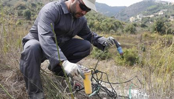
In March, Lebanon's Lampion Oil & Gas Services completed a ground magnetotelluric survey to complement the airborne survey being conducted by NEOS GeoSolutions. The local firm was subcontracted by US based Zonge International, which itself was subcontracted by NEOS, Lampion's Rachad Ghanem tells Executive. He explains that Lampion is collecting extra data to "calibrate" the data NEOS already collected from the air. According to an oilfield glossary written by the oil and gas services company Schlumberger, a magnetotelluric survey is a type of electromagnetic (EM) survey that measures "naturally occurring electric and magnetic fields at the earth's surface." Data gleaned from such a survey is used to "map subsurface resistivity variations," reports the website of Electromagnetic GeoServices (EMGS), a company that does these surveys. Resistivity is a measurement of "how strongly a material opposes the flow of an electric current," according to EMGS website. A report from Schlumberger further explains "some fluids (e.g. gas and oil) have very high resistivities while formation water and shales have low resistivities. These variations can help to discriminate between fluids." A magnetotelluric survey also gives a picture of the subsurface far deeper down than 2D or 3D seismic surveying, according to Schlumberger's glossary. While NEOS did take magnetotelluric measurements from the air, Lee Harper, the company's director of operations, explains in an email exchange that the ground survey "allows us to calibrate our airborne EM data, as well as enhance our overall data set. Ground [magnetotelluric] surveys are able to capture lower frequencies than airborne systems, which allows us to look deeper into the ground."
The real story
Contrary to a press report from January saying that NEOS would also conduct an onshore 2D seismic survey, the company is actually only incorporating 2D data shot by another company in 2013. "NEOS does not have plans to conduct any onshore seismic acquisition. Our Lebanon project will include the integration of some of the existing seismic [data], principally in the transition zone part of the survey area, into our interpretation and analysis," Amanda Jane, NEOS' project manager for the Lebanon survey, told Executive in an email exchange back in January. Jane said the Lebanese Petroleum Administration was expected to hand over the 2D data for incorporation by the end of January.
All eyes on Q2
The airborne survey finished in December 2014, according to a company press release, and so called 'first look' data became available to the survey's underwriters in February 2015. NEOS will not reveal who is underwriting the project, in line with standard industry practice, but the company's local partner, PetroServ, told Executive in October that it is underwriting the survey to the tune of $7.5 million. In a narrated slideshow describing the survey, NEOS reports that the project is moving ahead of schedule — 'first look' data was initially expected to be delivered by end of March. The slideshow says NEOS is "presently anticipating having the full interpretation ready for delivery on an accelerated basis at some point late in the second quarter," as opposed to by the end of September as originally planned. Once the data is fully analyzed, it will be available for purchase.
In a slideshow on its website describing the 'first look' data, NEOS includes some tantalizing information about clay and iron oxide deposits on the western margins of the Bekaa Valley. While the company has a commercial interest in talking up the results to sell more licenses to access them, misleading potential clients with embellishments would damage the company's credibility, meaning what they say about survey results thus far should be taken with a grain of salt, but not entirely dismissed as marketing mumbo jumbo. The deposits, the slideshow explains, are often a sign that oil or gas could lie below. "If you had hydrocarbon bearing intervals in the subsurface under Bekaa, these are the types of [indirect hydrocarbon indicators] one would expect to see and they are in the place where one would expect to see them."
Matt Nash
Executive
5 May


